|
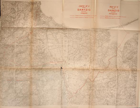
1919 map (from Treaty of Peace with Germany, Senate Doc. 51, 66th Congress, 1st Session (Government Printing Office))
Original Source Link. (Archive.org) |
|
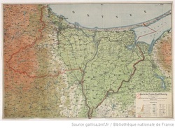
ca 1920-1922 (Westpreussen, Danzig und nördliches Polen)
Description: Scale 1:472 000 ; 1 map : col. ; 51x66 cm, on sheet 56x70 cm, folded to 29x15 cm ; Date of publication connected with activity of editor - name Carl Flemming, Verlag u. C.T. Wiskott AG was used in the years 1920-1932). Lack of railway lines opened after 1922 ; Prime meridian Ferro and Paris ; Ancillary map: region of Gdańsk in scale 1:150 000.
Original Source Link. (RCIN Digital Repository of Scientific Institutes)
|
Plan der Stadt Danzig : Angefertigt im Jahre 1920
Danzig mit Umgebung : Bebautes und freies Gelände Description: Skala 1:10 000 ; 1 mapa : litogr. ; 120x79 cm, złoż. 31x21 cm ; Tyt. z mapy ; Brak legendy do mapy ; Orientacja mapy północno-wschodnia ; Cyt. w: Klemp. - 2000, poz. 743, s. 88. Original Source Link. (RCIN Digital Repository of Scientific Institutes) |

|
Plan der Stadt Danzig : Angefertigt im Jahre 1921
Publisher: Verlag A.W. Kafemann G.m.b.H ; (Gisaldruck D. Lith. Anst v. Bogdan Gisevius).
Description: Skala 1:10 000 ; 1 mapa : litogr., kolor ; 118x77 cm, na ark. 125x74 cm, złoż. 31x22 cm ; Tyt. z mapy ; Orientacja mapy północno-wschodnia ; Plan kolorowany ręcznie, sztucznie dodane objaśnienia znaków.
Original Source Link. (RCIN Digital Repository of Scientific Institutes)
Karte der freien Stadt Danzig (1922)
Manteau, R. (18..-19..?), 1922. Karte der freien Stadt Danzig. 2nd ed. (s.l.): Danziger Verlags-Gesellschaft (Danzig).
Source: Bibliothèque nationale de France, département Cartes et plans, GE C-4102 (via The European Library).
Original Source Link. (Gallica)
Manteau, R. (18..-19..?), 1922. Karte der freien Stadt Danzig. 2nd ed. (s.l.): Danziger Verlags-Gesellschaft (Danzig).
Source: Bibliothèque nationale de France, département Cartes et plans, GE C-4102 (via The European Library).
Original Source Link. (Gallica)
1924 map. G. Freytag & Berndt Automobil- und Radfahrerkarten. Blatt 5, Danzig = G. Freytag & Berndt carte routière à l'usage des cyclistes et des automobilistes. Feuillet 5, Danzig = G. Freytag & Berndt motoring and cycling maps. Sheet 5, Danzig.
Danzig Blatt 5 ; G. Freytag &t Berndt carte routière à l'usage des cyclistes et des automobilistes ; G. Freytag & Berndt motoring and cycling maps ; Freytag et Berndt's Autostrassenkarten ; Freytag et Berndt's cartes routières pour automobilistes ; Freytag et Berndt's motoring maps.
Description: Scale 1:300 000 ; 1 map : col. ; 67x65 cm, on sheet 71x72 cm, folded in cover 21x13 cm ; Map title ; On the cover sheet index ; Date of publication from DNB online ; Legend of the map in English, French and German; geographical names in Polish.
Original Source Link. (RCIN Digital Repository of Scientific Institutes)
|
1926 map (from Carstenn, Edward. Führer durch Danzig)
Original Source Link. (Pomorska Biblioteka Cyfrowa) Linked here.
|
| ||
1927 map (Conrad L. Schadinsky Reklamebüro und Annoncenexpedition)
Scale 1:100 000 ; 1 map : col. ; 94x108 cm, on sheet 101x114 cm ; Ancillary maps: Plan der Danziger Hafens, Freie Stadt Danzig. On sheet : statistical data and index of hydrotechnical objects.
Original Source Link. (RCIN Digital Repository of Scientific Institutes)
Scale 1:100 000 ; 1 map : col. ; 94x108 cm, on sheet 101x114 cm ; Ancillary maps: Plan der Danziger Hafens, Freie Stadt Danzig. On sheet : statistical data and index of hydrotechnical objects.
Original Source Link. (RCIN Digital Repository of Scientific Institutes)
|
1922 map (from Pierwszy polski ilustrowany Przewodnik po Gdańsku i okolicy (1922))
|
| ||
|
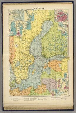
1922 map (from the David Rumsey Map Collection)
The Baltic Sea. George Philip & Son, Ltd. The London Geographical Institute. (1922) See inset, bottom right-hand corner. Original Source Link. |
|
|
1923 map (from Handlowa ksiega adresowa Polski i Gdanska), page 36 (display page number). Map of Poland and Danzig.
|
| ||
|
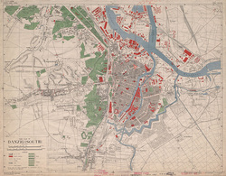
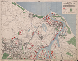
1936 map (this map was copied from a 1936 German map and published by the British War Office in 1944. Scale 1 : 19,000. [G.S.G.S. No. 4480])
Original Source Link (1). (British Library) Original Source Link (2). (British Library) |
|
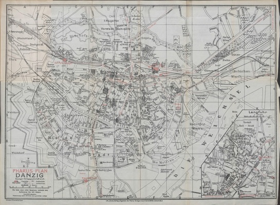
1938 map (Pharus-Plan Danzig mit Langfuhr)
Description: Skala 1:8 000 ; 1 mapa : kolor. ; 37x51 cm, złoż. w okł. 19x12 cm + skorowidz: 8 s. ; 19 cm. ; Tyt. z panela ; Mapa poboczna: Langfuhr, 1:17 000 ; W zał. tekst. reklamy ; Skorowidz ulic ; Data wyd. wg Klemp. - 2000., poz. 775, s. 90.
Original Source Link. (RCIN Digital Repository of Scientific Institutes)
1939 map (Poland with the Free territory of Danzig, East Prussia and Lithuania)
Description: Skala 1:650 000 ; 1 mapa : kolor. ; 61x51 cm, na ark. 71x56 cm ; Tyt. z mapy ; Mapy poboczne: Poland after Versailles; Warsaw (Warszawa) ; Data wyd. wg. WorldCat online i treści polityczno-administracyjnej mapy ; Tyt. i legenda w jęz. ang. treść mapy w jęz. pol. i niem.
Original Source Link. (RCIN Digital Repository of Scientific Institutes)